
Aquifer characterization is an important duty of the department's Water Resources Center. Northern Missouri relies heavily on surface water resources due to poor groundwater quality in bedrock aquifers. Northern Missouri is vulnerable to drought, which increases the need to explore additional groundwater aquifers to ensure safe and secure water supplies.
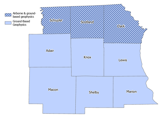
Unconsolidated surficial materials above bedrock can be aquifers and are promising targets for groundwater resources. The Northeast Missouri Aquifer Characterization Project focuses on discovering and describing unknown but suspected shallow buried channel aquifers in areas that rely on surface water and have poor groundwater quality. The project will cover nine counties in northeast Missouri: Clark, Scotland, Schuyler, Lewis, Knox, Adair, Marion, Shelby and Macon. This study’s goal is to find sources of potable groundwater to help landowners locate favorable water well construction sites, which may provide solutions to negative drought impacts on the region’s water supply.
The approach to this project includes three phases: calibration, measurement and prediction, and validation. The project will use three methods to collect data to complement existing data in the region: test holes, passive seismic data and airborne electromagnetic surveys. Each technology provides different types of data at different resolutions both vertically and horizontally, and consequently have different coverage areas. This data will be used together to predict the presence of channels.
Passive Seismic Data
Horizontal to Vertical Spectral Ratio (HVSR) technique is a type of passive seismic method that will be used on public lands throughout the study area. A device will be placed on the ground to record seismic readings from natural vibrations in the subsurface. This method provides depth to bedrock information without the need to drill; however, this method does requires calibration. A limited number of test holes will be drilled close to the center of the HVSR sites to properly calibrate velocity models of local unconsolidated materials for accurate depth to bedrock measurements from HVSR.
Test hole data will be used for calibration and validation. Test holes give us physical constraint on bedrock depth at specific locations. HVSR can use those physical depths to calibrate and measure depths away from test holes to identify probable areas for buried channel aquifers.
Airborne Electromagnetic Survey
An Airborne Electromagnetic (AEM) survey uses resistivity volumes to probe the subsurface, which is especially helpful with respect to water resources. AEM provides aquifer characteristics for identified channels. Water-rich formations and even saline versus freshwater character can be interpreted from geophysical volumes.
The department's Missouri Geological Survey (MGS) is contracting with SkyTEM and Aqua Geo Frameworks LLC to conduct these airborne surveys. This technique has previously been used for mapping of glacial aquifers in Nebraska, Iowa, North Dakota, Indiana and Illinois. The Missouri project began in 2025, with electromagnetic surveys in Clark, Scotland and Schuyler counties. The project is extending into Adair, Knox and Lewis counties this summer.
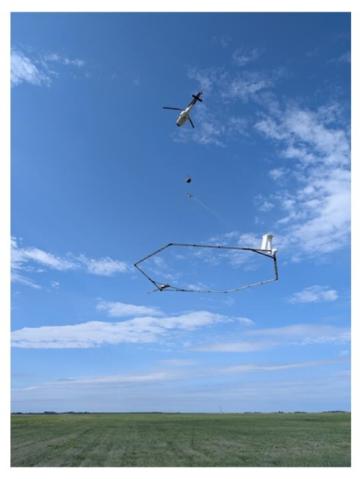
Through the end of July 2026, residents may see a low-flying helicopter towing a large hexagonal frame. The scientific equipment hangs about 100 feet below the helicopter in a spider web array. The equipment is designed to map geologic structures and groundwater resources down to approximately 900 feet below the land surface. The helicopter will be flown by pilots who are specially trained for low-level flying. For this study, the helicopters are flown by Heli-Worx Aviation. The helicopter company operates under FAA Unlimited Part 135 Unscheduled Air-Taxi Operations, Part 133 A,B,C and D External Loads, and Part 137 Agriculture Dispersal certifications.
The flight paths are designed to gather the best available underground data. Since data can only be collected over open spaces, no data collection will occur over residential areas, livestock feeding operations or other buildings. After the flights, Aqua Geo Frameworks LLC will use the data to produce a 3D hydrogeological framework and final report for MGS.