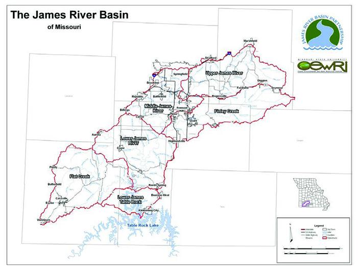

The largest tributary of the White River in Missouri, the James River stretches about 150 miles, from its headwaters in Webster County to the White River (now Table Rock Lake) in Stone County. The 1,455 square miles of the James River Basin covers parts of eight counties in southwest Missouri. The majority of the basin lies in Webster, Greene, Christian, Barry and Stone counties, with only very small portions overlapping into Lawrence, Wright and Douglas counties. The James River receives major tributaries at Pearson Creek, Wilsons Creek, Finley Creek, Crane Creek and Flat Creek. The James River 8-digit Hydrologic Unit Code (HUC8) subbasin (HUC #11010002) is further divided into six smaller HUC10 watersheds: Headwaters (Upper) James River, Finley Creek, Wilsons Creek (Middle James River), Crane Creek (Lower James River), Flat Creek and Lower James-Table Rock.
Land uses across the James River Basin vary widely. Agriculture is generally predominate in the upper and lower ends of the basin, with urban and suburban uses in the central part. Nearly 50% of the land in the James River Basin is in agricultural uses, with cattle raising the most prevalent type of farming use. Most of the livestock are on grasses and grasslands, which make up about 47% of the land use in the basin. Cultivated croplands comprise less than 1% of the basin. Forests make up about 38% of the land cover in the basin. Urban and suburban development now make up about 11% of the James River Basin land use, about 165 square miles. The basin’s three largest cities, Springfield, Nixa and Ozark, have a combined area of about 100 square miles or 6.9% of the basin’s total land area. However, much of the growth is in the metropolitan areas outside these city limits.
Water Quality Issues
Water quality in the James River basin is generally fair to good, but there have been serious problems in the past, some of which continue to the present day. Several waterbodies in the James River Basin are included on the state’s 303(d) list as impaired for beneficial uses. Although all pollution sources are not identified, those that have been are linked to both point source and nonpoint source pollution, with nonpoint source pollution as the main cause.
| Impairment | Waterbody | Cause/ Source |
|---|---|---|
| E. coli | Gallaway Creek* | NPS |
| James River | NPS | |
| Pearson Creek | NPS | |
| Ward Branch* | NPS | |
| Wilsons Creek | NPS | |
| Aquatic Macroinvertebrate Bioassessments (loss of biotic diversity) | Crane Creek | Unknown |
| Pearson Creek | Unknown | |
| Wilsons Creek | NPS/ Unknown | |
| Polycyclic Aromatic Hydrocarbons (PAHs) | Jordan Creek | Urban NPS |
| zinc | N. Branch Wilsons Creek | Urban NPS |
| Chlorophyll-a | Lake Springfield | NPS |
| Chlorophyll-a, total Nitrogen, Nutrient/ Eutrophication Biological Indictors | Table Rock Lake | Municipal PS/ NPS |
PS = point source pollution; NPS = nonpoint source pollution
*Listed on the 2022 draft 303(d) list of impaired waterbodies
Water quality problems in the James River Basin relate to both urban and agricultural land uses. A James River Nutrient Total Maximum Daily Load was approved in 2001, and updated in 2004, to address nutrient impairments in the James River. The nutrient concern was addressed by wastewater treatment plant upgrades. However, nutrient levels in the river remain above the desired or “target” levels in several areas, so there remain violations of the narrative criteria for nutrients.
Watershed Management Plan
The Southwest Missouri Council of Governments completed a James River Watershed Management Plan, which provides a framework for maintaining and improving water quality in the James River and its tributaries. The James River is no longer considered impaired for nutrients, but implementing this watershed plan will preserve and protect beneficial uses in the James River and other streams and groundwater in the James River Basin. The plan identifies reasonable, appropriate and cost-effective best management practices (BMPs) to be used on farms, residences and development projects to reduce pollution. It is there to assist organizations, agencies and public entities in their water quality related efforts, including developing realistic budgets for future watershed projects and practices. The plan attempts to set reasonable and realistic timelines for getting these BMPs into place. It also lays out ideas for evaluation and monitoring (e.g. water quality testing) programs to help determine how successful the plan is in protecting water quality in the James River and its tributaries. The Southwest Missouri Council of Governments anticipate 20 years would provide enough time to secure funding and allow the plan goals to be met.
Project Goals
The overarching goals and objectives of the James River watershed-based plan are to:
- Improve the quality of waters within the James River basin that are listed as impaired
- Guide the implementation of future programs and practices in ways that address impairments most efficiently and effectively
- Provide direction for multiple agencies, organizations and political entities as they apply measures to improve water quality
Below is a summary of the anticipated load reductions or removal efficiencies that will be obtained by installing the BMPs as provided in the James River watershed-based plan.
- Vegetated stream buffers in agricultural (pasture) areas. Estimated 34% reduction in total Nitrogen, 34% reduction in total Phosphorus and 20% reduction in sediment.
- Vegetated stream buffers in urban areas. Estimated 6% reduction in total Nitrogen, 9% reduction in total Phosphorus and 4% reduction in sediment.
Best Management Practices
- Animal agriculture BMPs: vegetative buffers along streams, managed or rotational grazing, fencing livestock out of streams and alternative watering systems
- Poultry operations BMPs: managing litter spread on fields to prevent nutrients and/ or bacteria from reaching streams or groundwater and exporting litter from the basin to areas of crop production where the litter will have beneficial nutrient value
- Crop agriculture BMPs: vegetative buffers along farm fields, crop rotations, cover crops and no-till.
- Urban and urbanizing area BMPs (at individual homes, residential subdivisions, shopping centers, commercial or industrial sites, parks or other developed areas): stormwater detention basins, extended detention basins, retention basins, vegetated buffers, green spaces, rain gardens, green roofs and biofilters. These BMPs are designed to reduce soil erosion and downstream sedimentation and to reduce polluted runoff.
- Construction site BMPs: silt fences, silt socks, gravel construction entrances, sediment basins, and seeding or hydro-seeding and mulching exposed soils
- Other BMPs: Stream bank stabilization, regular maintenance of on-site wastewater (septic) systems and replacement or repair of all or part of a failing or leaking systems, riparian corridor improvement, tree planting, timber stand improvement

