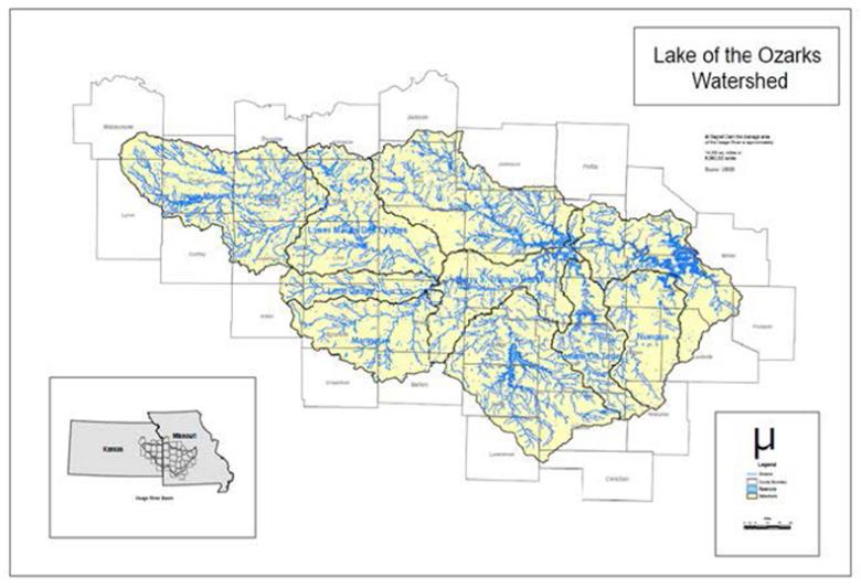

Lake of the Ozarks, also referred to as LOZ, is a reservoir created by impounding the Osage River in south-central Missouri, approximately 45 miles southwest of Jefferson City. The lake was created in 1931, with the construction of Bagnell Dam. LOZ has a surface area of approximately 54,000 acres and 1,150 miles of shoreline, making it one of the largest manmade lakes in the world. The Lake of the Ozarks 8-digit Hydrologic Unit Code (HUC8) subbasin (HUC #10290109) is further divided into four smaller HUC10 watersheds: Cole Camp Creek-Osage River, Big Buffalo Creek-Osage River, Grandglaize Creek and Gravois Creek-Osage River.
Though built to provide hydroelectric power, LOZ quickly became a tourist destination and a key economic driver for the state of Missouri and region. Parts of three smaller tributaries to the Osage River are included in the lake: the Niangua River, Grand Glaize Creek and Gravois Creek. The lake east of the Niangua Arm is highly developed, while west of the Niangua Arm has limited development in specific areas. The land around the lake is an area of steep hills and valleys, springs and streams. Where the land is not developed, the land cover is predominantly forest.
Developed areas of the lake continue to rapidly urbanize, with residential and commercial structures visible around much of the lake. Population around the lake increased steadily from 1990 to 2007. From 1990-2020, Camden County population almost doubled. The ability to work from home remotely altered the local demographics of the lake area from seasonal recreation to year round inhabitant as well.
Water Quality Issues
Years of development, transformation of near-shore landscapes, in-water recreation and other activities generated concerns with the potential for water pollution and other stressors on water quality. Stakeholder concerns included waste and pollution of dense populations, largely unregulated or poorly regulated development, unmanaged stormwater, unmaintained and eroding shorelines, and aging or malfunctioning on-site wastewater management systems (septic tanks).
In 2020, the Lake of the Ozarks was included on the state’s 303(d) list as impaired. The cause of impairment was listed as eutrophication (excess nutrients and chlorophyll) from nonpoint source pollution.
Watershed Management Plan
In 2006, stakeholders held public meetings to identify, discuss and prioritize environmental concerns around the lake and the impact land uses were having on the lake. The main concerns included sediment, bacteria, nutrients, wastewater and shoreline damage and trash. As a result of those meetings, the Lake of the Ozarks Watershed Alliance (LOWA) was formed to proactively work at maintaining and improving the water quality of LOZ and its surrounding watershed, up to Truman Dam in Warsaw, which is located more than 90 river miles west of Bagnell Dam.
In 2010, LOWA drafted a non-regulatory watershed management plan to address water quality concerns at that time. The entire watershed basin for LOZ is 8,960,000 acres, with a substantial portion extending into Kansas. This is an impractical scale for any single watershed planning effort. With this in mind, the watershed management plan focused on the Lick Branch and Buck Creek subwatersheds, located in the more developed areas of the lake, nearest to Bagnell Dam.
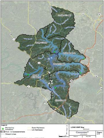
With LOZ's impaired listing in 2020, it was determined the watershed management plan needed to be updated and expanded to address the identified sources that caused and contributed to the impairment. The updated plan is intended to build on the original plan, continue the momentum and capacity, and expand opportunities within four additional subwatersheds. The focus area consists of six HUC12 subwatershed, comprising 136,947 acres in Camden, Miller and Morgan counties.
- Lake of the Ozarks Watershed Management Plan Update, May 14, 2024
- Lick Branch - HUC 102901090406 (update)
- Buck Creek - HUC 102901090407 (update)
- Indian Creek - HUC 10290190404
- Soap Creek - HUC 102901090405
- Linn Creek - HUC 102901090401
- Porter Mill Bend - HUC 102901090207
The total watershed area reflected in the updated plan is 136,947 acres (214 mi2). This part of the LOZ watershed was chosen because it is home to the first shorelines to be developed. The water quality of this area also has the potential to be altered by the waste and pollution of dense populations and original developments that were constructed under limited regulation. Pollutants of concern for this focus area are total phosphorous and total nitrogen in sediment. Sediment is known to carry nutrients. Total phosphorous is of particular concern as it can trigger excessive aquatic plant growth or algal blooms. The table below provides the estimated pollutant loads for nutrients and sediment within in the six HUC 12 focus areas.
Watershed | Nitrogen Load | Phosphorus Load | Sediment Load |
|---|---|---|---|
Indian Creek | 53,990 | 9,205 | 2,145 |
Soap Creek | 57,513 | 10,649 | 2,541 |
Lick Branch | 33,648 | 6,089 | 1,626 |
Buck Creek | 52,732 | 9,548 | 2,314 |
Porter Mill Bend | 41,530 | 8,056 | 1,973 |
Linn Creek | 86,028 | 15,491 | 3,514 |
Total | 325,442 | 59,037 | 14,115 |
Project Goals
Many of the goals and strategies identified in the 2010 watershed management plan continue to be applicable. The updated plan builds upon those efforts while also presenting opportunities for achieving numeric project implementation goals, targeted at reaching specific load reductions for each of the watersheds contributing sediment and nutrients to the lake.
Goals
These goals are intended to result in an evolution of the water management plan and continuing to promote LOWA’s ongoing work in the following manner:
- Responsible Development: This is and will continue to be a need in a rapidly changing watershed. Development will continue to advance. It is through implementing this water management plan that environmental impacts of development can be appropriately managed.
- Community Engagement: Seeking community recognition by governmental entities within the water management plan focus area demonstrates a commitment to the principles and preservation of the lake.
- Continued Engagement and Recruitment of Stakeholders: With this plan, LOWA is proposing to expand relationships with more stakeholders to increase the reach and membership to promote their mission of the water management plan.
- Numeric Quantification and Implementation Goals: Over the course of the 30-year water management plan, LOWA is proposing to reduce nutrient and sediment loading within the respective watershed by 10%.
Strategies
- Strategy 1: Educations and Outreach
- Strategy 2: Runoff Management and Control
- Strategy 3: Seawall/ Riprap
- Strategy 4: Maintain and Grow Water Quality Monitoring Program
- Strategy 5: Municipal Self-Assessment
- Strategy 6: Champions of Wastewater
Best Management Practices
The updated watershed management plan focus area is predominantly forested, with forested land covering 74%. Pasture lands, primarily at higher elevations, make up 6% of the focus land area. Developed or urban areas of varying density make up 20% of the focus land area. Most of the development in the watershed management plan focus area is near the lake. The plan identifies reasonable, appropriate and cost-effective best management practices (BMPs) to be used. Examples of BMP’s recommended for implementation:
- Shoreline Restoration: involves working within the existing footprint of the shoreline and requires minimal hard armoring. Shoreline restoration involves temporary erosion control practices during construction and vegetative reestablishment as a means to protect shorelines from wave action.
- Vegetative Filter/ Buffer Strip: vegetated areas that receive stormwater runoff from pastureland associated with animal feeding operations; filter strips must include fencing as part of the practice.
- Bioswale and Bioinfiltration Basins: vegetated, shallow, landscaped depressions designed to capture, treat and infiltrate stormwater runoff. Stormwater runoff is filtered through soil planting beds before moving downstream.
- Vegetated Swale: constructed stormwater conveyance systems designed to achieve water quality and quantity benefits. This practice aims to filter and trap pollutants, improve water quality, attenuate peak flow and/ or promote infiltration while limiting groundwater contamination.
- Yard Low Impact Landscaping (LIL): rain garden/ bioretention cell
- Native Vegetation
LOWA and the stakeholders have had success implementing LILs such as vegetated and infiltration swales, terraces, native planting buffers and shoreline protection. Shoreline improvements prioritize protecting shorelines with any measure.


