Missouri Geological Survey Director: Carey Bridges, RG
Commodity
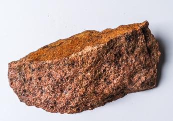
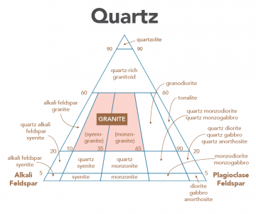
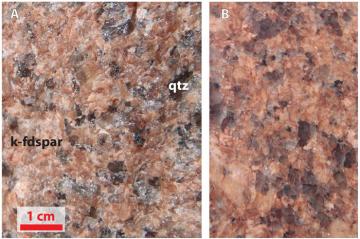
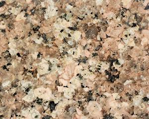
Granite is a general commercial term for decorative building stone that is hard and crystalline. Commercial granite may include granite, gneiss, syenite, monzonite, granodiorite, anorthosite or larvikite or any phaneritic igneous or metamorphic rock. Black granite is a particular kind of commercial granite that when polished, is dark gray to black. It may be a diabase, diorite or gabbro. Geologists consider granite as any holocrystalline, (composed entirely of crystals large enough to see with the naked eye) (Figure 3) quartz-bearing plutonic (cooled slowly in the Earth) igneous, rock. More specifically, granite is a plutonic rock in which quartz constitutes 10-50% of the felsic components and in which the alkali feldspar/total feldspar ratio is restricted to the range of 65-90%. According to the IUGS (International Union of Geological Sciences) classification (Figure 2), granite is a plutonic rock containing 20-60% quartz and a ratio between feldspars types (plagioclase and K-feldspar) between 10-65%. The IUGS classification of granites will be followed in this report.
Economic Importance
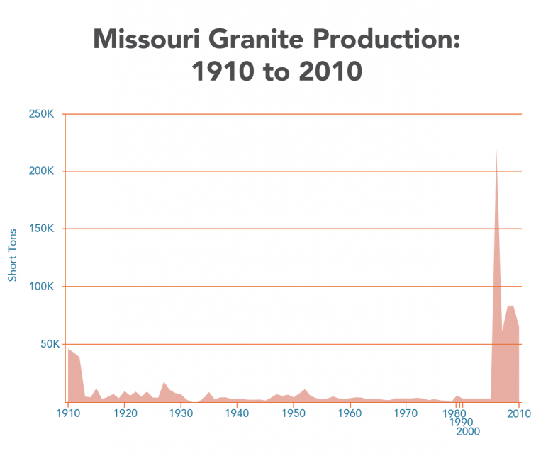
The Graniteville Granite, also known as “Missouri Red,” along with other granites from Missouri, has been used in monuments and architectural projects across the nation and around the world. In 2010, Missouri produced more than 60,000 short tons of dimension and crushed granite with a value that exceeded $500,000. Crushed granite and monumental dimension stone comprises nearly all of Missouri’s entire granite production. The demand for “Missouri Red” and other monumental granites likely will not decrease. The increasing use of crushed granite for ornamental and road building further secures a promising future for granite production in Missouri.
Chemical and Physical Properties
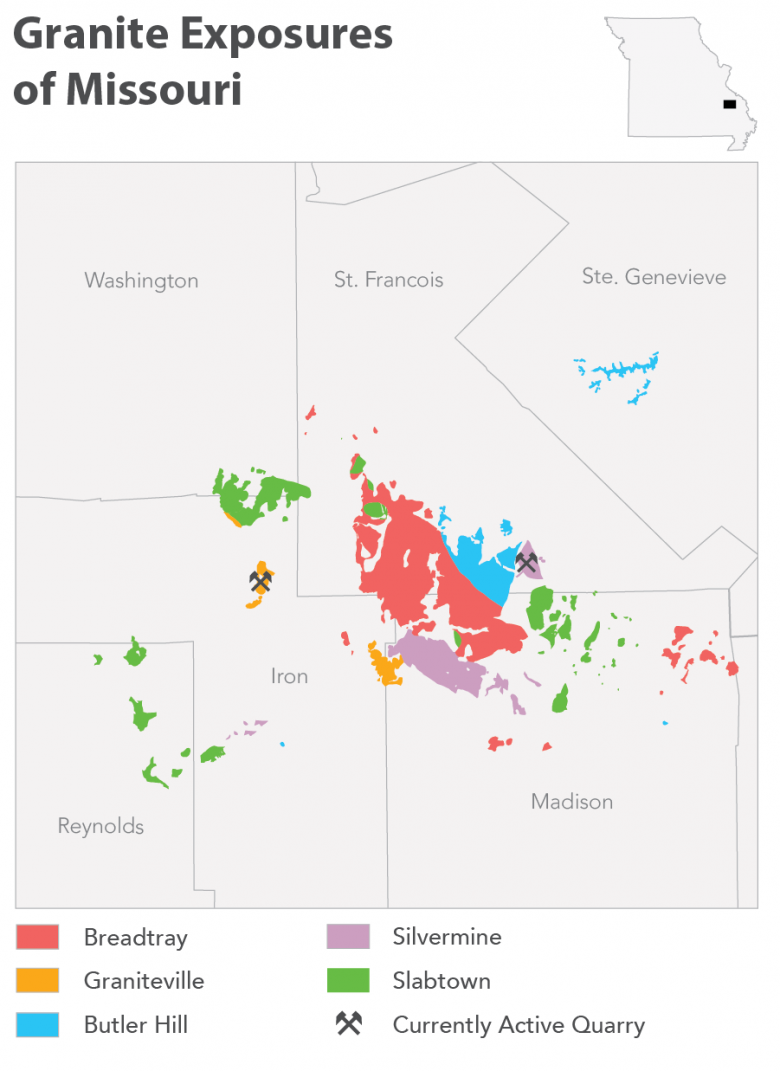
Missouri granites contain large amounts of the minerals quartz and feldspar. They contain lesser amounts of plagioclase, hornblende, biotite, muscovite, chlorite and epidote. The specific amounts of these minerals vary depending on the particular granite. Many of the granites contain trace amounts of sericite, sphene (titanite) and fluorite. Granite is often found in rounded outcrops created by spheroidal weathering such as best exemplified by the spherical boulders of weathered granite at Elephant Rocks State Park (Figure 1). Upon closer inspection, the crystalline nature of these rocks becomes apparent to the observer (Figure 3). The Missouri Geological Survey has traditionally recognized five main types of granites. Included are the Butler Hill, Breadtray, Graniteville, Silvermine and Slabtown granites. These types are based on mineralogy and rock texture. The mineralogy is directly related to the original composition (Table 1) of the magmas that intruded beneath the large ash-flow volcanic centers exposed in southeast Missouri during what geologists call the Mesoproterozoic, 1.4 to 1.1 billion years ago. The Butler Hill, Breadtray and Graniteville granite are quite siliceous (>70% SiO2). The Silvermine and Slabtown granites exhibit slightly less silica than the other types of Missouri granites.
| Chemical Composition | Butler Hill Granite | Breadtray Granite | Graniteville Granite | Silvermine Granite | Slabtown Granite | Other Granites |
|---|---|---|---|---|---|---|
| SiO2 | 74.72 | 75.19 | 76.01 | 69.53 | 71.15 | 72.75 |
| Al2O3 | 12.35 | 12.24 | 12.09 | 14.91 | 13.12 | 13.76 |
| Fe2O3 | 1.80 | 1.46 | 1.38 | 1.44 | 1.90 | 2.35 |
| FeO | 1.17 | 0.52 | 0.48 | 1.63 | 1.61 | 1.56 |
| MgO | 0.28 | 0.22 | 0.08 | 0.87 | 0.59 | 0.44 |
| CaO | 0.92 | 0.73 | 0.75 | 1.60 | 1.14 | 0.96 |
| Na2O | 3.54 | 3.95 | 3.70 | 4.33 | 4.73 | 3.79 |
| K2O | 4.37 | 4.38 | 4.55 | 3.94 | 3.50 | 4.40 |
| H2O+ | 0.61 | 0.33 | 0.22 | 0.78 | 0.67 | 0.51 |
| H2O- | 0.13 | 0.10 | 0.05 | 0.13 | 0.13 | 0.10 |
| TiO2 | 0.25 | 0.09 | 0.10 | 0.35 | 0.43 | 0.30 |
| P2O5 | 0.04 | 0.03 | 0.03 | 0.14 | 0.15 | 0.07 |
| MnO | 0.11 | 0.02 | 0.01 | 0.06 | 0.06 | 0.08 |
| LOI | 2.12 | 3.09 | 0.33 | 0.83 | ||
| Total | 100.26 | 99.77 | 99.29 | 99.73 | 99.88 | 99.65 |
| Physical Properties | ||||||
| Specific Gravity | 2.64 | 2.64 | 2.62 | 2.71 | 2.67 | 2.68 |
| Absorption wt. percent | 0.39 | 0.26 | 0.61 | |||
| LA Wear wt. percent | 20.52 | 23.63 | 16.26 | |||
| Na2SO4 5 cycles | 0.85 | 0.68 | 0.16 |
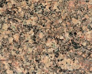
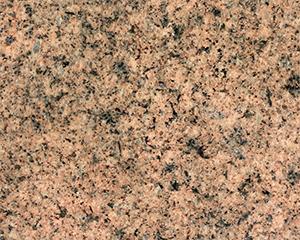
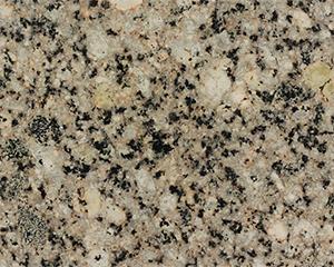
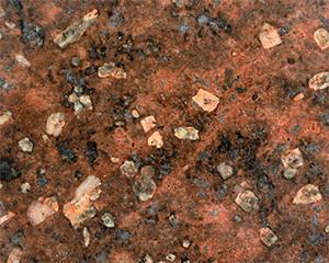
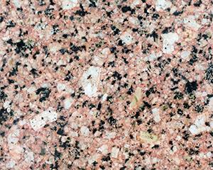
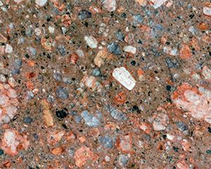
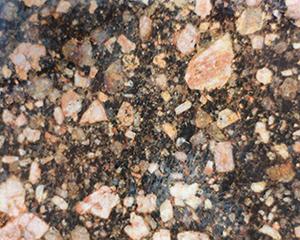
Showcase of Missouri Granites
| 
| 
| ||
| 
| 
| 
| 
|

| 
| 
| 
| 
|
| 
|
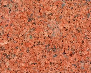
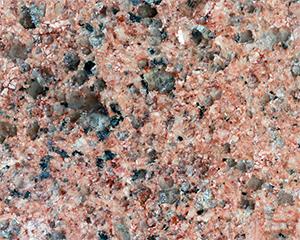
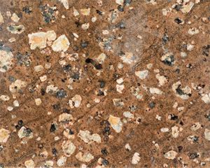
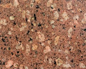
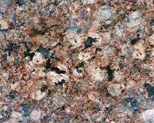
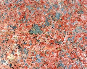
Due to differences in mineralogical composition and differences in cooling rates, the colors and textures of the granites are quite different. The coarsest-grained granites, such as the Graniteville, cooled very slowly allowing some of the feldspar and quartz crystals to grow larger than 1 cm in length. Some of the granite porphyries have large crystals set in a groundmass of small (almost microscopic) crystals. These textures are thought to be created by a crystal-rich magma interacting with colder surrounding country rock. The quick loss of heat resulted in not enough time for larger crystals to grow; hence, many small (microscopic) crystals grew instead.
Occurrence
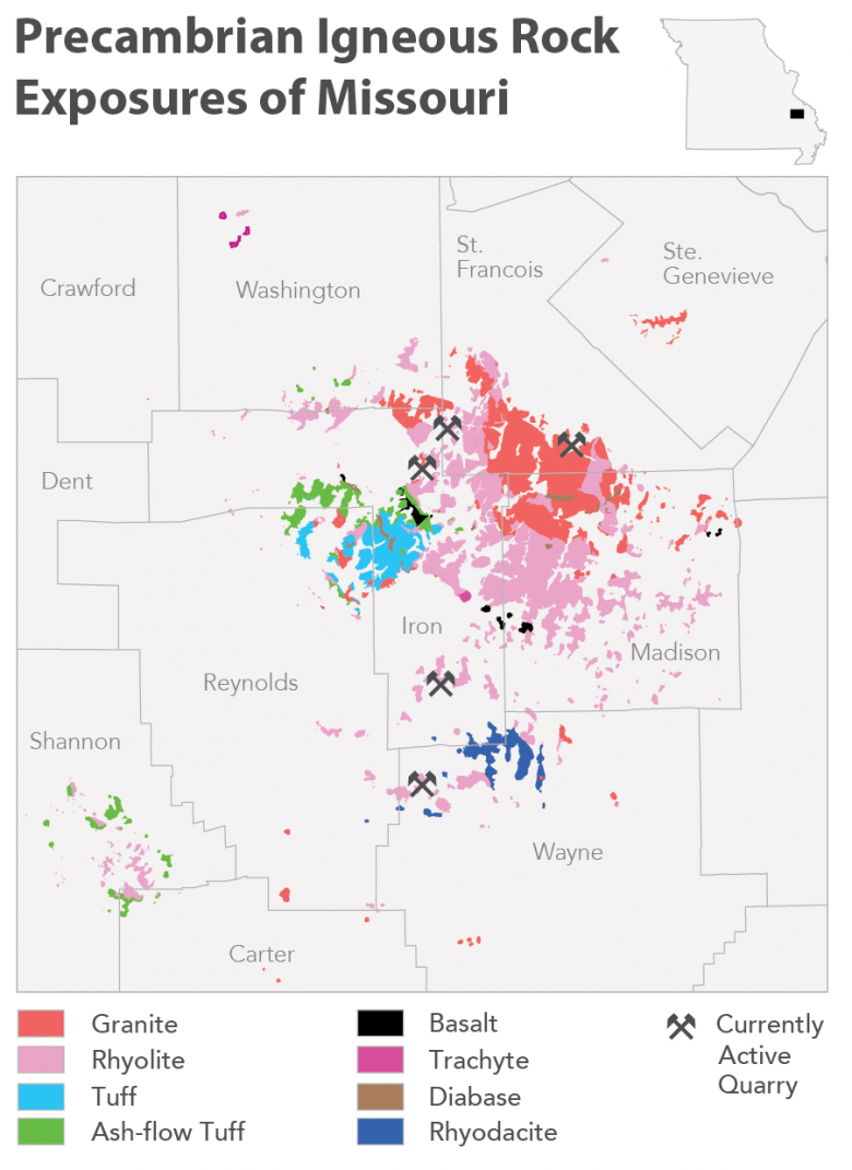
The St. Francois Mountains of southeast Missouri consist of exposed knobs of Precambrian igneous rocks, including volcanic rocks and granites (Figure 5). It is from these Precambrian igneous rocks that granite is produced. The knobs form the highest portion of the Ozark Dome. Paleozoic deposits exist only as thin veneers between individual knobs, thus providing additional underground granite resources between the knobs. The Precambrian exposures have an area of nearly 350 square miles (900 km2). The outcrop area includes nine counties: Wayne, Carter, Shannon, Reynolds, Iron, Madison, Washington, St. Francois and Ste. Genevieve. Granite outcrops are restricted to Carter, Washington, Reynolds, Wayne, Madison, Iron, St. Francois and Ste. Genevieve counties. A Precambrian exposure map (1:125,000 scale) is available for downloading from the U.S. Geological Survey. The Missouri Geological Survey presently is revising the Precambrian exposure map. More detailed maps are available for purchase from the Missouri Department of Natural Resources' Missouri Geological Survey.
Primary Uses of Missouri Granite
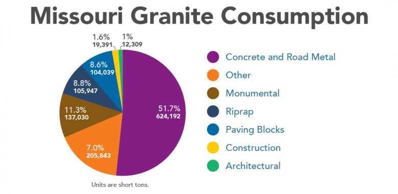
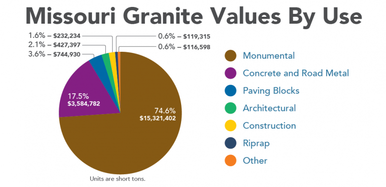
Missouri granite is currently and primarily used for monumental purposes and road building. Current and historical reported uses include:
- Paving Blocks (Historical)
- Riprap – River and Lake Shore Improvements
- Construction
- Building Foundations – Rubble Stone
- Architectural
- Stone Veneer
- Monuments, Mausoleums and Headstones
- Road Materials
- Foundations
- Pavements (Road surface)
- Gutters (Historical)
- Curbing (Historical)
- Bridges and Culverts (Historical) (e.g., Eads Bridge, St. Louis)
- Railroad Ballast
Historical Uses of Missouri Granite
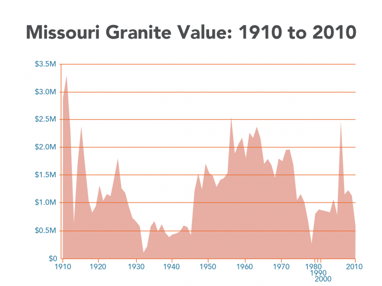
Granite usage is from 1910 to 2010 with much of the 1980s and 1990s data not available.
| 
|
Dollar values have not been adjusted for inflation. Granite values are from Granite Value
1910 to 2010 with much of the 1980s and 1990s data not available.
Granite Value 1910 to 2010
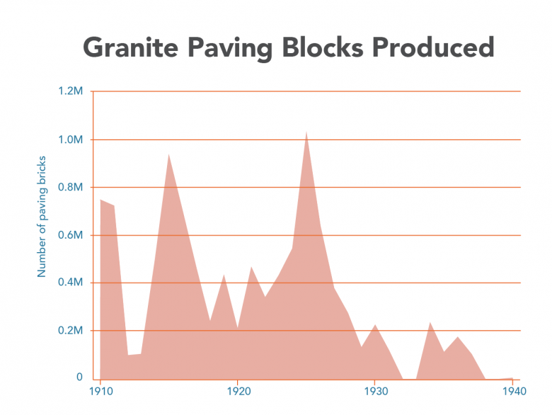
Paving blocks constituted a large portion of Missouri’s early granite production. These blocks were used to pave streets in Missouri and in places such as Memphis and Chicago. Paving blocks were quarried by the larger dimension stone quarries and smaller operations called “motions.” These motions were often one or two-person operations that quarried paving blocks from granite boulders strewn on the ground. Read more about how paving blocks were produced. The demand for granite paving blocks was at its height from the 1880s to 1890s. Demand for paving blocks decreased in the first half of the 20th century. The year 1940 saw the last reported production of paving blocks in Missouri. Granite Paving Blocks Produced 1910 to 1940.
Production History
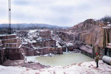
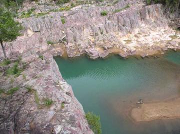
Missouri has produced granite since the mid-19th century. The first reported significant use of Missouri granite is from a quarry an Iron County quarry in
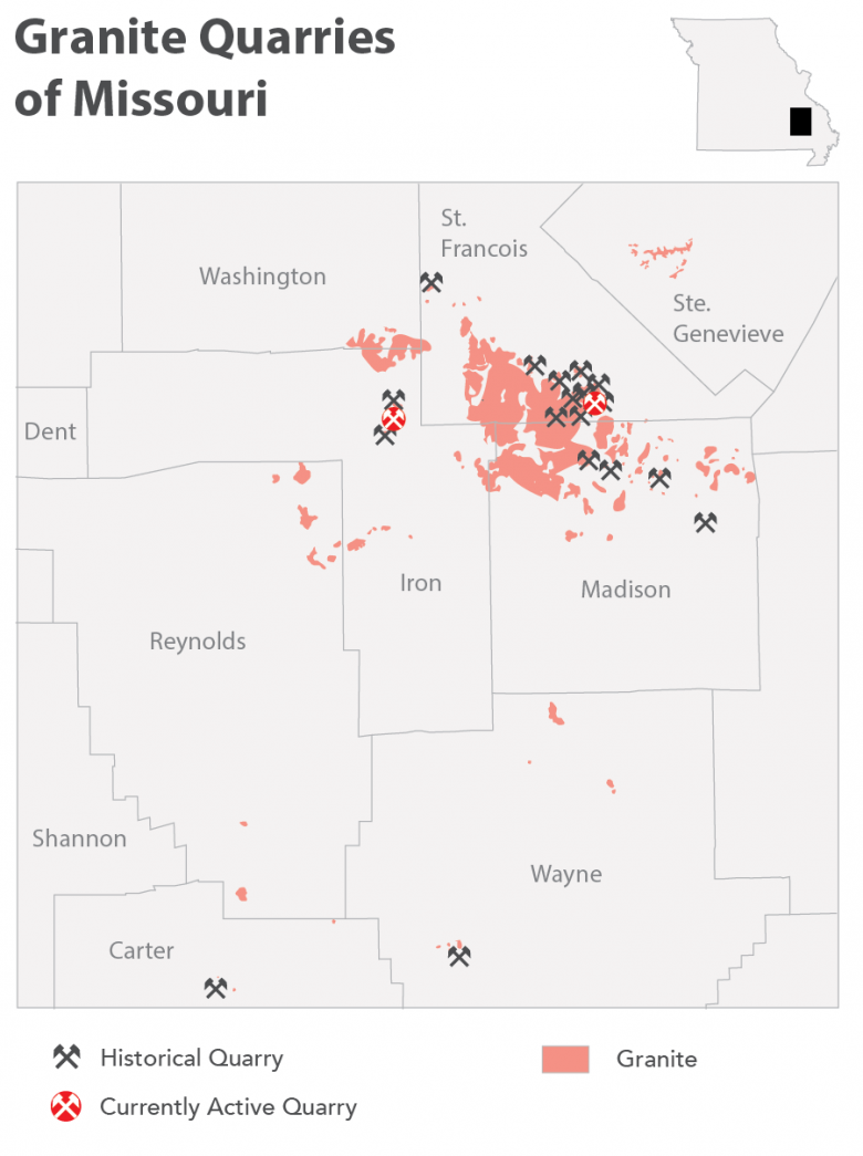
Graniteville, owned by U.S. Senator B. Gratz Brown. The granite was used for the footings of the Eads Bridge constructed from 1867 to1874 in St. Louis, Missouri. The four granite columns of the Missouri governor’s mansion also came from this quarry. The first extensive quarry operation was opened by Phillip Schneider at Graniteville. In 1876, Milne & Gordon opened a quarry at Syenite, St. Francois County. During 1883, Syenite Granite Co. resumed work at Graniteville in the quarry previously operated by Schneider. In 1889, the Sheahan Bros. opened a quarry at Graniteville. The Sheahan family continued to quarry granite from their Graniteville quarries well into the mid-20th century. See historical granite quarry photos and advertisements.
Common Terms Used in the Granite Industry
- Dressed stone – Dimension stone that has been cut with a saw or polished.
- Rough stone – Dimension stone as cut from the quarry working face.
- Rubble – Loose, irregular pieces of artificially broken stone as it comes from the quarry.
References and Further Reading
Buckley, E.R., and Buehler, H.A., 1904, The quarrying industry of Missouri. Missouri Bureau of Geology and Mines Volume 2, 2nd Series, 371p. Electronic copy available by contacting 573-368-2100.
Ladd, G.E., 1890, Building stones, clays, and sands of Iron, St. Francois, and Madison counties, Missouri. Geological Survey of Missouri Bulletin No. 1., p. 22-44. Electronic copy available by contacting 573-368-2100.
Le Maitre, R.W. (editor), 2002, Igneous rocks, A classification and glossary of terms, 2nd Edition. Recommendations of the International Union of Geological Sciences, Subcommission on the Systematics of Igneous Rocks, Cambridge, UK, 236p.
Neuendorf, K.K., Mehl, Jr., James P., and Jackson, J. A. (Editors), 2011 Glossary of geology. American Geosciences Institute, Alexandria, VA, 783p.
Search the Missouri Geology Bibliography
Visit the department’s Ed Clark Museum of Missouri Geology, where you will find granite on display.
Nothing in this document may be used to implement any enforcement action or levy any penalty unless promulgated by rule under chapter 536 or authorized by statute.
For more information
Geological Survey Program
Missouri Geological Survey
P.O. Box 250
Rolla, MO 65402-0250
United States

